PORTRAIT OF THE SEAHOUSES NORTHUMBERLAND (UK) NORTH SEA SHORELINE
Civilisation has long dictated that one of the most desirable places to live is adjacent to a safe seashore. So there must be untold numbers of dwellings qualifying for the term "sea houses".
And yet submitting the single-word version, "seahouses", into any search engine with world-wide geographical scope yields but a single result (or you can send us a correction!). It is to be found at -
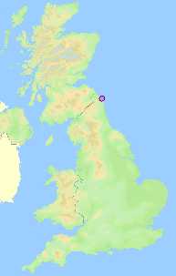
- Latitude 55.58° north: Longitude (-)1.65° west.
- The UK's national Ordnance Survey grid system gives the village centre a reference of NU 2232.
- A typical Main Street shop such as the Post Office has a post code, NE68 7RQ.
- The what3words designating the doors of the lifeboat station are pavement.hypnotist.film.
Arrival would prove that the shoreline consists of long, wide sandy beaches backed by dunes both north and south of the village, which itself is built on a major outcrop of limestone and sandstone on which the stability of the harbour relies.
If you had been long-retired, a resident of the area for several years; and if you took an interest in your environment; and if you had opted for near-daily constitutional beach walks with your dogs, camera and litter-picker; and if you found a certain satisfaction and fulfilment in constructive authorship; and if you had access to the technology of the time; then perhaps you might have tried to tell the world about the Seahouses shoreline. You might even have decided to split the story up into sections describing those wide wave-swept sands; their wind-formed dunes; and the rocks and cliffs which recorded the tectonic history of the more-nearly permanent features. And, blessed with a concrete path that traverses the whole tidal range of the seaweed zones, that biology can be displayed too.