ROCKS AROUND SEAHOUSES
Quite apart from the kind of rock that has "Seahouses" running right through it, there are lots of rocks under and around the village and beaches of Seahouses. There's a lot to see once you start exploring the cliffs and tidal rocks, especially just south of the harbour and village.
(With GPS it is possible to pin-point features of the landscape. Many of the photographs here include details of lat/long and OS grid reference for the benefit of anyone who's
that interested. The lat/long locations are given both in conventional figures and also in the decimal format used by Google. For all-numeric grid references NU=46. This first one is at 55° 34' 47" N, 001° 38' 39" W :: 55.579828, -1.644225 :: NU 2252 3185.)
THE DIFFERENT KINDS OF SEAHOUSES ROCKS
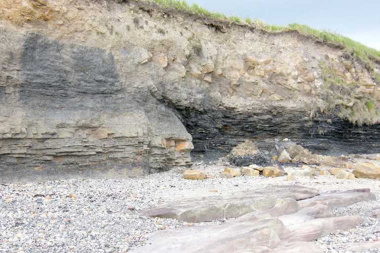
Perhaps the most significant rock in the area is "limestone".
(55° 35' 43" N, 001° 40' 23" W :: 55.595231, -1.673147 :: NU 2070 3356 on north beach and 55° 34' 35" N, 001° 38' 32" W :: 55.576331, -1.642347 :: NU 2264 3146 on south beach.)
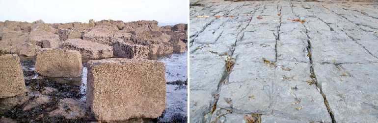
Any rock that seems to be in more or less regular blocks is likely to be limestone. All limestones were formed millions of years ago from the chalky remains of microscopic organisms living in warm tropical seas. Over immense periods of time the soft ooze was compressed and hardened into a fairly hard rock. Limestone has been very important in the history of Seahouses, having been the mineral used to produce quicklime in the kilns, as explained on the display boards at the harbourside.
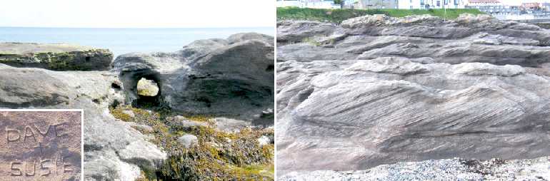
Another rock that you find, around the harbour for example, is "sandstone".
(55° 34' 56" N, 001° 38' 42" W :: 55.582278, -1.644881 :: NU 2248 3212 and 55° 34' 57" N, 001° 38' 43" W :: 55.582444, -1.645144 :: NU 2246 3214.)
Whereas limestone tends to crack and break into blocks, sandstone wears away without cracking, often leaving odd shapes. Any dry rock around Seahouses with particles that glisten in the sunlight is sure to be a sandstone. It's a fairly soft rock as rocks go, so it's a prime target for ardent lovers! On the other hand, some exposed sandstones still show ripple marks or layering from when they were first laid down.
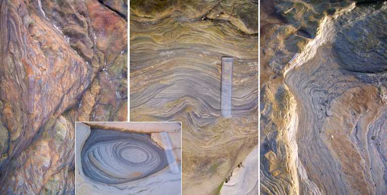
When ancient muds became compressed by later rock layers that accumulated above them they formed other types of relatively soft rocks - even softer than sandstone.
(Anywhere on the rock area around 55° 35' 07" N, 001° 39' 39" W :: 55.585250, -1.660958 :: NU 2147 3245.)
(That's a 15cm, 6" ruler to give a sense of scale.)
This nearly always happened in relatively quiet water environments, so any layering was preserved in the resulting "mudstone" or "clay rock" (of very fine particles) and "siltstone" (of slightly larger water-carried particles): you can be excused if you call them all "shales" instead. Almost like tree-rings, the layers might have differed from year to year or century to century: we see the result as contrasting colours, often exposed as remarkably artistic patterns.
Exceptionally, the uppermost shale layer south of Seahouses is made up almost entirely of shells.
(55° 34' 34" N, 001° 38' 37" W :: 55.576242, -1.643667 :: NU 2256 3145.)
"Brachiopods" were (and still are) sea creatures equipped with top and bottom shells hinged at the 'back', so to speak. They flourished throughout most geological times: scientists have catalogued some twelve thousand different species - but we don't know what kind ours were!
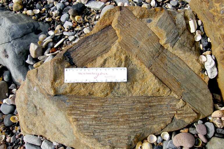
Smallest in volume but of greatest interest, Seahouses boasts its own coalfield!
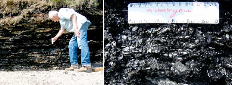
(55° 34' 48" N, 001° 38' 40" W :: 55.579903, -1.644481 :: NU 2251 3186.)
(That's another 6", 15cm ruler.)
In fact it was local coal that was used in the limekilns, but it was a limited resource so no significant mining has taken place since those days. Seahouses coal occurs mainly in soft, thin layers among the mudstones, having been formed from the remains of tropical forests.
All these rocks (yes, coal does count as a "rock") are called "sedimentary" rocks, because they originally accumulated as sediments over long periods of time. If you are intrigued by the references to "tropical" seas and vegetation you need to know that when these rocks were formed Seahouses - or what would one day be Seahouses - was very close to the Equator! It is the three-hundred-million-year movement of our continental "plate" that accounts for our now being 55½° north.
IF YOU'D LIKE MORE TECHNICAL DETAIL ...
At the beginning of the Carboniferous Period continental stretching took place parallel to the Iapetus Suture of super-continent
Pangea resulted in the formation of, among others, the Northumberland-Solway Trough. This left the land surface close to sea level. The outcome over the next 50 million years or so was the accumulation in the Trough of some 2½ km depth of Yoredale Cyclothems - successive layers of marine ooze forming limestone; soil particles washed in by rivers forming mud- and siltstones; sand deposited by river deltas; and swampy coal-forming forests. Seahouses is more or less in the north-south middle of that erstwhile Trough. The layers outcropping at the Seahouses cliffs are of the Alston Formation, including the Eelwell Limestone.
There are no metamorphic rocks in the immediate vicinity of Seahouses village, but there was the well-known intrusion of dolerite or "Whinstone" at 295 million years BP. It formed the Whin Sill and thus the core of the Farne Islands and the base of Bamburgh Castle as well as features south of Seahouses including the foundations for Dunstanburgh Castle and Hadrian's Wall. It is likely that some distortion and faulting of our local sedimentary layers took place at the time.
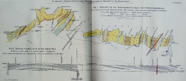
A Professor Lebour studied all the various layers of limestones, shales, sandstones and coals in this area. He took account of their compositions, present day exposures and angles of dip, as well as limited amounts of information from nineteenth century drillings. He was able to deduce the way they must have been laid down originally and subsequently been faulted, deformed and eroded.
His major finding, published in 1884, was that the line of the present-day Annstead Burn marked the position of a really massive fault line, the Annstead Fault, running east-west: Beadnell layers finished up something like 950 or 1,150 feet higher than the corresponding Seahouses deposits - as shown by the dotted line. Otherwise undisturbed, subsequent relentless erosion levelled things off to the 'edgy' contours visible today.
OK, so that's the ancient history. After a very long gap in the geological record, Seahouses bears evidence of what happened in the last ¼-million years. Several major ice ages followed one another. When snow accumulates over prolonged periods the sheer weight compresses all except the top surface into more or less solid ice. But that huge mass, up to 1 km thick at times, could grind its way slowly down-hill. In the process it scraped off whatever got in its way, dumping all of it only when it eventually melted during a subsequent warmer "interglacial" period. Anything removable near here finished up in the area now forming the North Sea. But in return the final glacier flowing down south-eastwards brought us some Cumbrian and Scottish material!
(55° 34' 35" N, 001° 38' 36" W :: 55.576272, -1.643436 :: NU 2257 3145.)
And that's what all the brown stuff is. It consists of the fine clay and coarser particles that the glacier ground off the immoveable rocks, plus larger particles, stones and anything up to boulders carried down within the mass of ice. Its origin and nature give it two common names: "glacial till" and "boulder clay". Any boulder carried in this way, if it's clearly not native to where it finishes up, is called an "erratic".
Our local final glaciation was the 'Devensian', ending about 11,000 years ago.
CHANGES TO SEAHOUSES ROCKS
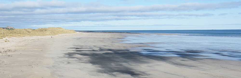
It would be wrong to imagine that history happened and then stopped. Nothing is permanent. The forces of nature continue their inexorable recycling of materials on a timescale of mind-numbing proportions. But the effects can be seen between one visit and the next. Perhaps most obvious is the movement of sand.
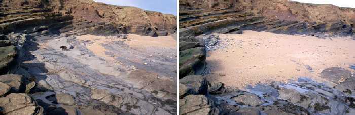
(55° 34' 37" N, 001° 38' 24" W :: 55.576817, -1.639997 :: NU 2279 3152.)
Winds cause waves: waves can agitate and carry sand. But this should not be thought of as a simple movement from A to B. Sand is carried only when the water is in motion, acting like a very dilute but effective grinding paste on the surface of whatever can't get out of its way. Some small indication of the forces at work is shown by the way the measurable levels of sand change as hundreds of tonnes are moved on-shore and out again later in this small cove. During incoming and outgoing tides pebbles are constantly rolled over and around too, grinding against each other, rounding off any corners, and liberating fresh particles to add to the grinding paste.
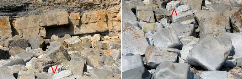
(55° 34' 39" N, 001° 38' 24" W :: 55.577403, -1.640003 :: NU 2278 3158.)
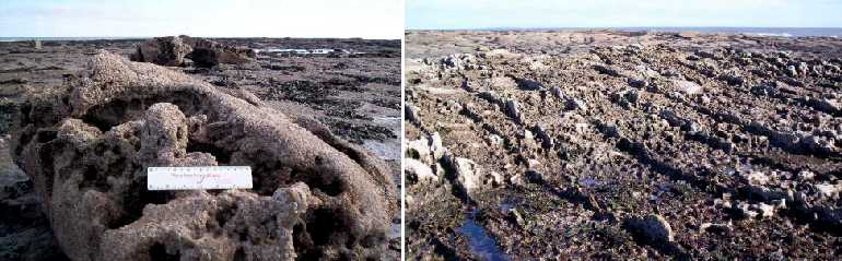
The effect on larger rocks is seen here. Characteristically square-edged blocks of limestone have finally come away from the cliff in the left-hand picture. After exposure to countless tides and innumerable wave actions their predecessors, pictured right, have had their corners and edges worn away: abrasion rules! (That's the same rock arrowed in each picture.)
Layered rocks including the mud- and siltstones can have layers or patches that are much softer than their surroundings.
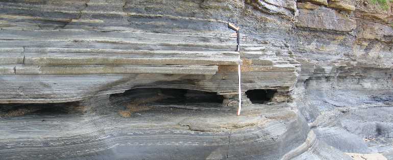
(55° 34' 37" N, 001° 38' 25" W :: 55.576864, -1.640153 :: NU 2279 3153.)
So under the eternal bombardment of gritty waves those patches are the first to be eroded away.
Unlike the white cliffs of Dover (which are all chalk and quite vertical) what can happen where there are rock layers being eroded at different rates is that the sea can wear away foundations of soft rocks, leaving harder rock suspended above it.
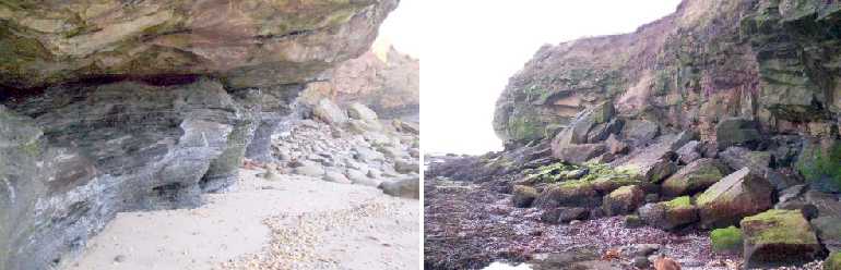
(55° 34' 45" N, 001° 38' 37" W :: 55.579294, -1.643694 :: NU 2256 3179 and 55° 34' 45" N, 001° 38' 35" W :: 55.579208, -1.643033 :: NU 2260 3177.)
A cave may form for a while, as has happened - or is happening (present tense) - just round the corner from Snook Point. But sooner or later something gives way and the upper layers break up and collapse onto the beach. Such major events are very rare, but -
- our looser upper layers come apart more easily, and more frequently.
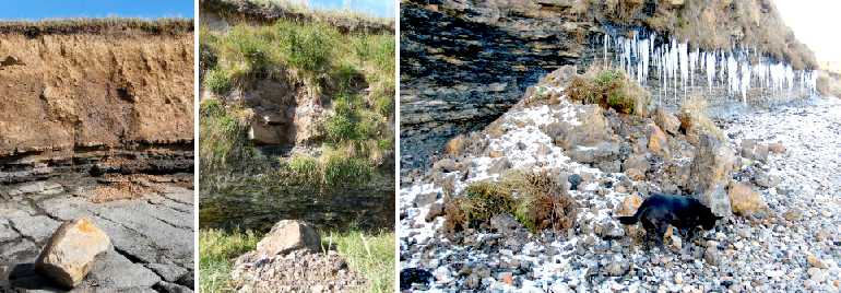
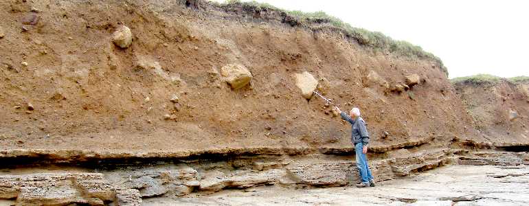
Heavy rain, or gentle rain over a long time, washes the finer clay and silt particles away from the boulder clay where it is exposed above our beaches: the inevitable result is that from time to time a sizeable boulder loses its support and tumbles down, health and safety notwithstanding. The centre example shows the release of a block of limestone and some glacial till when the soil and vegetation around it lost stability. Our biggest recent (2009) example concerned many tonnes of limestone, other rocks and boulder clay collapsing onto Braidcarr beach, just south of the harbour. Whereas the two left-hand examples were brought about by rainwater, alternating freeze and thaw were almost certainly responsible for the big one on the right.
Another mechanism which might be accelerated by frost is the coming apart of any layered rock.
But most 'delamination' is brought about by the sea, at any temperature. You may find what looks like a sore place where there is a gap in the colouring brought about by the life forms living on the normal surface of the rock. But occasionally it is possible to spot a biscuit-like item freshly released from its millions-of-years siesta: there may be adjoining flakes that can be lifted off with the fingers.
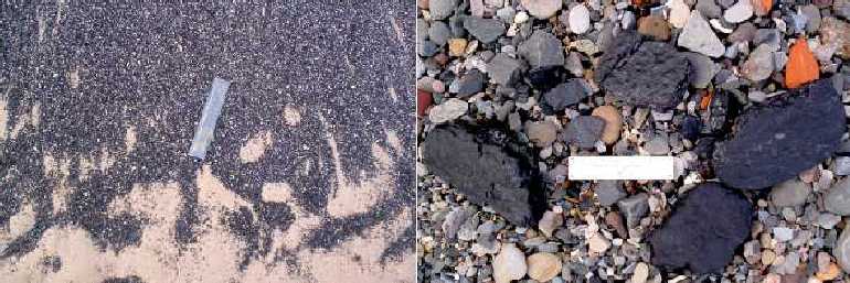
Also broken up, but usually into finer particles, are Seahouses offshore coal layers.
In the nature of the case, there must be other coal seams, similar to the ones we can examine in the cliffs, lower down the rock formation out at sea. The churning action of currents, tides and waves combine to ensure that any material coming away is soon reduced to what is virtually coal sand: we find minor patches of it on beaches both north and south of Seahouses from time to time.
Very occasionally some combination of wave action and tides can result in the appearance of a more substantial area of coal sand. It probably continues to be worn away until it becomes invisible, never spoiling our 'golden sands'. It should be realised that the coal sand is noticeable only because it's black: all the other rocks of the shore are constantly being reduced to sand too.
A totally different circumstance arose when the harbour and yacht basin were dredged in 2008. The excavators penetrated some thicker coal deposits so that later wave action revealed some quite worth-while lumps of coal suitable for household use - which is, indeed, what happened to a lot of them!
In an earlier age attempts were made to find industrially significant sources of coal.
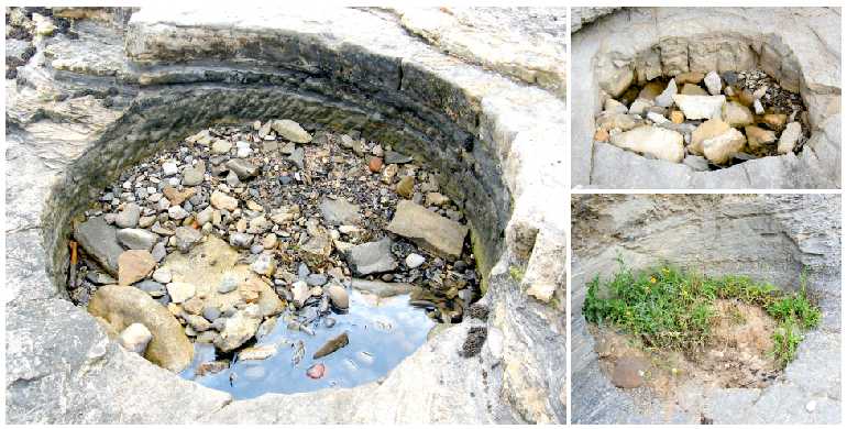
(Left at 55° 34' 36" N, 001° 38' 26" W :: 55.576658, -1.640519 :: NU 2276 3150. Upper right at 55° 34' 34" N, 001° 38' 37" W :: 55.576242, -1.643667 :: NU 2256 3145 and, below, a slightly less obvious one eaten into the cliff at 55° 34' 38" N, 001° 38' 25" W :: 55.577306, -1.640206 :: NU 2278 3157.)
Some nice neat holes were left to posterity by explorers of that earlier age. Exact details are uncertain but local historian Katrina Porteous has found references to drillings in the area dated between 1823 and 1856. She has also discovered that as early as 1899 the official geological map made several references to "Old Shafts" and more specifically "Old Coal Shaft". So if they were "old" then, there is little wonder that they lack the uniformity associated with more modern technology: the diameters of our three are variously 5ft 5", 6ft, and 6ft 6". (The note on the "Old Coal Shaft" reported "Bore hereabouts got Eelwell limestone 26' on coal 5" at 9½ fathoms limestone 4'4" at 16 fathoms coal, mostly foul, 4'9" at 24 fathoms". Another site slightly further inland revealed "4' coal, mostly stone, at 9 or 10 fathoms". [1 fathom = 6 feet.] All that work must have constituted a considerable investment at the time.)
An altogether different kind of disturbance may, rarely, have occurred during the actual formation of a mudstone layer.
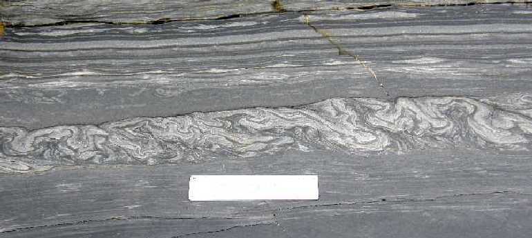
(55° 34' 37" N, 001° 38' 24" W :: 55.576831, -1.639875 :: NU 2280 3152.)
Just one ancient group of layers were evidently mixed up, almost certainly by primitive mud-living creatures of the time in search of even lowlier life-forms as food. Such stirring is known as bioturbation. It is slightly unfortunate that this only known example near Seahouses is more often than not obscured under a variable depth of mobile sand.
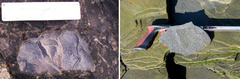
But much more significant alterations took place shortly - just a few million years - after the bulk of the rocks had been laid down.
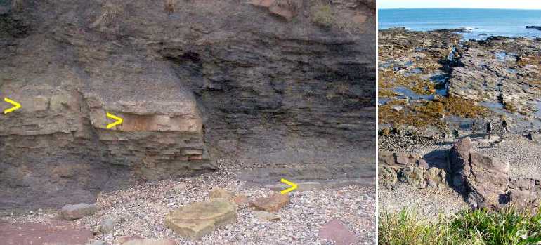
(55° 34' 47" N, 001° 38' 39" W :: 55.579828, -1.644225 :: NU 2252 3185.)
When there are significant movements of the earth's crust the rocks are sometimes able to bend and tip. Beyond those limits the rocks crack and move bodily, suddenly, creating a fault accompanied by an earthquake. The yellow-arrowed layer here was originally all one continuous, more or less level deposit. Viewed from the Coast Path at the top of the cliff that same fault can be seen as a slightly curved step going up the middle of the picture. There are some folk (and their shadows), near-centre right, to help gauge the sizes involved. (The early geological map measured it as "Fault 4¾ feet".)
Strange to relate, although limestone had its origin in the sea it dissolves in water!
(Right-hand picture: 55° 34' 38" N, 001° 38' 21" W :: 55.577242, -1.639219 :: NU 2284 3156.)
To be more specific, limestone slowly dissolves in rainwater, especially acid rainwater. So with plenty of time at its disposal, it can reduce any limestone block to a pretty moth-eaten appearance. Where there's a whole layer the limestone itself may disappear, leaving in situ any other kind of rock that had previously infilled the joints between the blocks, perhaps now sticking up for you to trip over.
Another, totally different way that rocks can be reduced in size is by storm-wave action, lifting loose rocks as if they were just big bits of sand!
Of course, like anything else, rocks weigh a lot less in water than they do in air. So perhaps it's not quite so remarkable that a lift-and-drop action can break them up. (But this kind of demonstration is not one that you'll find every day.)
Sooner or later the combined effects of several types of weathering can break boulders off solid rock. Chemical dissolution has evidently combined with physical battering by waves to weaken and finally fracture the chunk of Snook Point shown below (from November 2012). Thus are created a new generation of boulders: the scars of fresh surfaces will soon be colonised by invading plants and animals.
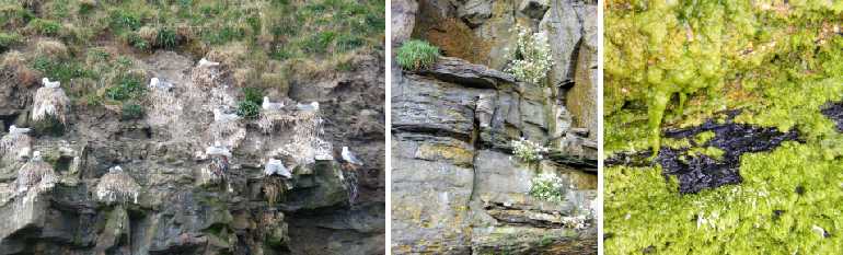
Living things can have an effect in the weathering of rocks on the seashore as on mountains, cathedrals and elsewhere.
The very welcome kittiwakes and fulmars who nest on the rock ledges below the golf course produce waste products which coat the rocks and accelerate chemical actions. Ordinary common sea-cliff plants such as the scurvy grass (in flower) and thrift in the centre picture can establish themselves in minute cracks in the rock. Growth and expansion of their roots tends to expand the cracks too. In addition, carbon dioxide produced by their roots makes the moisture more strongly acid than it would otherwise be. The acidifying effect is even more marked with some primitive plants related to mosses which live in damp sheltered hide-away spots: they behave like a sponge holding onto moisture, which becomes even more acid at nights, again due to carbon dioxide.
WHAT'S IN AND ON SEAHOUSES ROCKS
Let's be clear from the start, there's no Jurassic Park anywhere near Seahouses! But there are several Carboniferous patches. Much the biggest and certainly the richest is the Annstead fossil bed.
(55° 33' 55" N, 001° 38' 15" W :: 55.565258, -1.637575 :: NU 2295 3023.)
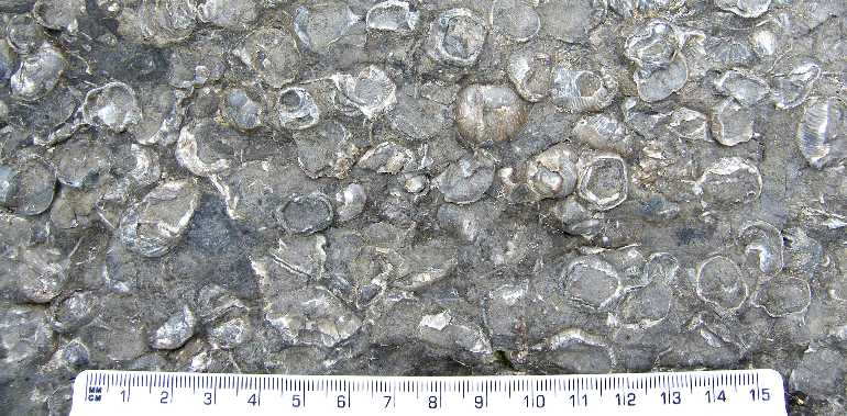
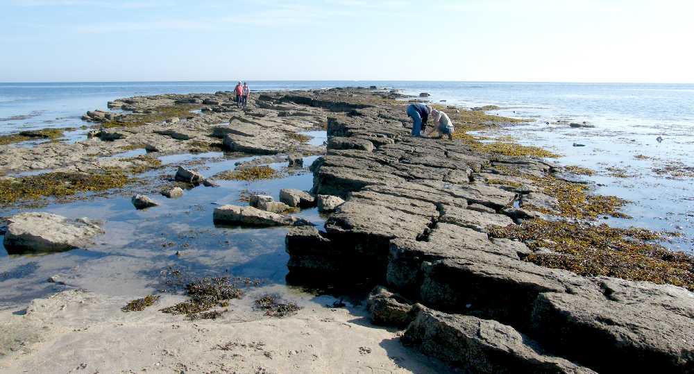
As you'll have guessed from this picture, it gets completely covered at high water twice daily: these explorers were lucky to catch it at mid-tide. It's not possible to fix any helpful marker post. The location is well down towards Beadnell, just before reaching the Link House - which you can't see from the beach, though you might see its access path! Anyway, what you'll find if you do find it is this stepped series of limestones of which the top two or three have half a dozen small fossils in almost every square metre from the shore sand to the waterline, wherever it is at the time. Those fossils are almost exclusively crinoids.
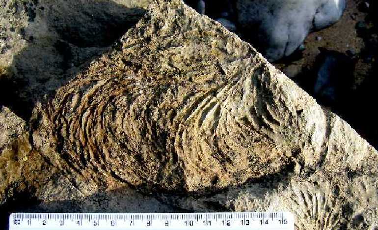
There are bigger and better individual crinoid fossils much closer to Seahouses among the southernmost golf course rocks.
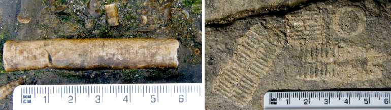
(Right-hand picture: 55° 34' 35" N, 001° 38' 25" W :: 55.576514, -1.640169 :: NU 2278 3148.)
Crinoids were simple animals that looked like plants. The body seemed to be a stem: the feeding arms seemed like equal branches normally five in number. You can look up as many details as you want using Google or Wikipedia so there's no need for a longer explanation here. The Seahouses crinoid fossils are in among the carboniferous limestone layers, around three hundred million years old. They mainly consist of sections through the stems or arms, though the left-hand picture is of a small entire piece of stem. Both stem and arms were almost exactly circular in cross-section, and they were all made up of sections (called ossicles) giving a ladder-like appearance lengthways. It was because the ossicles came apart so easily that virtually all crinoid fossils are made up of broken bits rather than whole 'limbs'. (Modern crinoids are feather stars - like starfish.)
Other fossils in the limestone layers include those of the very successful group of "brachiopods" - simple marine animals with upper and lower shells. Among the Seahouses residents were these -
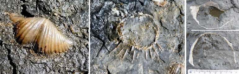
(Left and centre: thanks to Ian Kille.)
On the left is a typical brachiopod shell fossil, of a Spirifer. The centre picture is of an altogether different view, in this case including some of the external spines which are rarely preserved, of a productid brachiopod. But Seahouses can also boast of at least two specimens of the biggest of all the productids, given the impressively appropriate name of Gigantoproductus: it must have been a substantial handful by our standards!
But it's not the case that only shells can be fossilised. It may come as a shock to associate Seahouses with coral reefs, but (a) there are such things as cold-water corals, now, out there at sea though they don't form reefs, and (b) Seahouses was tropical when these rocks were laid down.
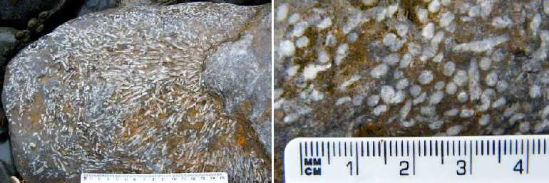
(55° 34' 39" N, 001° 38' 24" W :: 55.577500, -1.640111 :: NU 2278 3159.)
So if you find a rock that looks as if it's been spread with bits of spaghetti or packed with white circles it's very likely to be the fossilised remains of the ancient coral known as Siphonodendron.
Those were fossilised bits of actual organisms. There are also patterns or other marks as moulds or imprints left behind in the sediments by organisms which have disappeared.
The so-called stigmaria shown here are fossil imprints from coal forest trees. The larger specimen on the left appeared after the harbour was dredged. It is likely to have originated as a piece of tree root. The specimen on the right is a small part of what is probably an imprint of the Carboniferous "Scale Tree", Lepidodendron. It was spotted as a pebble on the beach. (Whereas nearly all Seahouses fossils are built-in, diligent search among greyish pebbles can occasionally yield a small fossil, usually a crinoid, that can be taken home.)
A rock fall on Braidcarr beach was shown earlier. Among the interesting rocks that finished up being washed clean by their first tides for a few million years was a small sandstone - yes, sandstone - boulder with a triple fossil in it.
It was evidently a carboniferous fossil wood pile! The pieces of material arranged in a triangle are the fossilised remains of trunks of a tree fern (Sigillaria possibly) interleaved with some sediment and then quite thoroughly compacted. It's an unusually clear example.
But an altogether different type of built-in fossil is the Cock's Tail!
(55° 34' 38" N, 001° 38' 25" W :: 55.577306, -1.640206 :: NU 2278 3157.)
That was the local name given to these quite noticeable patterns that are relatively common on the surface of Seahouses limestones. Little is known about them for certain, so the scientists call them Zoophycus being uncertain as to their animal or seaweed origin. Best bet is that they were lines left behind by some worm-like creature during its feeding forays.
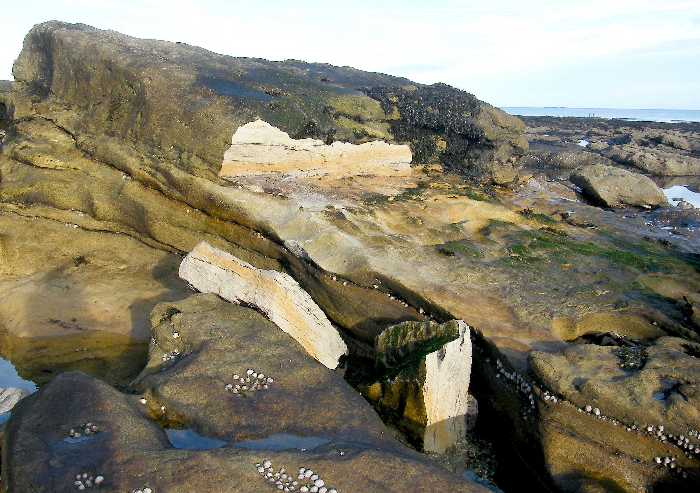
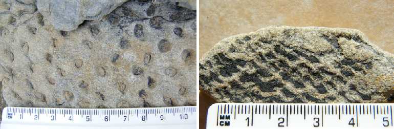
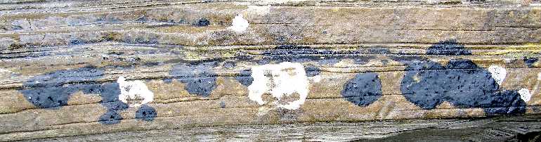
Other slightly mysterious objects are ironstone nodules.

(Around 55° 34' 40" N, 001° 38' 25" W :: 55.577700, -1.640175 :: NU 2278 3161.)
It is thought that they form by purely chemical processes. Some are relatively large and isolated while others may be dotted across a layer within the sandstone or shale (not limestone): or they may be mixed. It is not unknown for significant nodules to be collected and used locally as an iron ore.
In a category of its own - what's missing from Seahouses rocks? Who's been making holes in them?
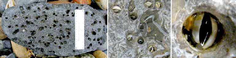
The answer is "piddocks". We're not now talking about ancient creatures: piddocks are at work now, albeit largely under water rather than on the beaches. They are small oyster-like bivalve molluscs with the ability to waggle the toothed edges of their shells so effectively that they can grind out protective recesses in rocks. There are lots of different kinds: you could look up details of the 'common piddock' under Pholas dactylus for example. By the time big pebbles arrive on the dry shore some of the holes may well have been colonised by other organisms, but the right-hand close-up is believed to be a genuine piddock portrait.
There's a multitude of living things on the surface of coastal rocks.
Hardly any inland rock is left bare for very long: lichens and mosses and the like soon invade and form a living surface. At the seaside there is the complication of salt spray which severely limits the range of organisms tough enough to thrive. But they do exist, as witnessed by these black and white lichens: they characterise the marine splash zone, and provide reassurance to some visitors perhaps that our black splodges aren't crude oil after all!
Life exists everywhere. As well as the lichens on the surface, other plants find enough water, plant food and shelter in the apparently inhospitable cracks between rocks.
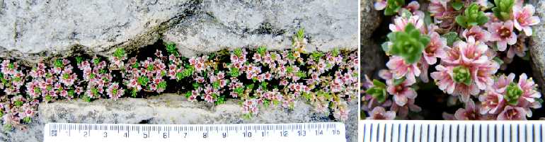
Evidently avoiding much in the way of salt spray, this saxifrage keeps a very low profile in one of the regular limestone fissures. (Thought to be purple saxifrage, Saxifraga oppositifolia, the leaves look 'wrong' because the foreshortened stems prevent the normally oblong leaves spreading out.) The ecology of the foreshore can include many types of plants invading from their normal homes inland, if only on a short-term basis. In the other direction, looking down-slope, seaweeds, barnacles, limpets and whole ecosystems are to be found. But they're to be found on a different page: click on the "zonation" link below to explore further.
CODA
(55° 34' 39" N, 001° 38' 24" W :: 55.577478, -1.639978 :: NU 2279 3159.)
It may be worth mentioning again the timescales we've been dealing with. Nearly all the Seahouses rocks were laid down as sediments between 350 and 290 million years ago. The figures trip off the tongue alright but it takes a moment for realisation to dawn. These layers are obviously different: the lower white limestone was there before the black shale accumulated on top of it. Was there some catastrophic convulsion that suddenly changed shallow sea to muddy fresh water? Perhaps there had been other layers in between but they were eroded away before the black mud arrived. Equally likely, that white-black boundary may represent a gap of perhaps ten million years - that would have been five thousand times the whole of the Christian era from the first Christmas to today, or some one hundred and fifty thousand lifetimes! And that's just the possible GAP from white to black!
<<<<<<<<<<+>>>>>>>>>>
Perhaps it might have been nice to have described something akin to a Geological Trail with guide-posts and numbered exhibits. But half the fun of exploration lies in making discoveries for yourself. Seahouses is already famous for its harbour facilities and wonderful sandy beaches. We hope the descriptions and pictures above will have encouraged you to add extra value to your visit by having a look at some of the rocky patches too. The relevant National Geological Survey map is England sheet 4, "Holy Island". It shows an astonishing twenty bands of coal among the limestone layers. Both the layering and the faulting are unusually complex in the Seahouses-to-Beadnell coastal area.